The Aran Islands - a bleak but scenic day excursion


Galway town is beautiful in its well laid out design,
its nice shops and tourist areas, its pubs and helpful friendly folk. See my Galway
blog as it’s not fair to the city to tie it up with Aran Islands. One needs a
few days in Galway as apart from the town itself which you can see over two days,
you need to go to the Aran Islands, Connemara as well as other sights nearby.
The day after my arrival in Galway, I left for the Aran Islands and the day
after for Connemara (another blog). My enjoyment of Galway was regrettably left
to the time after the tours.
I had seen leaflets of different tour operators and felt
that an Aran islander might be the best guide to show the island. I was wrong
as my tour driver / coach owner was frankly more interested in packing as many
tourists as possible on the coach and then leaving us on the island rather than
taking us up the highest point as far as possible which he could only do with a
minivan on the small lanes of the island.

I went with Michael Faherty Tours which left Galway at
9.30 am via Spiddel. We had to get to the ferry point, an hour’s drive away - massive
beautiful clouds which changed colours as the sun played hide and seek, undulating
green fields, rolls of hay waiting to be picked up. Beautiful countryside. At 10.20
am, we reached Roskillen ferry point. A
small village which has the ferry and fishing as its main activity.

Throughout Ireland, I found hundreds of Spanish and
French students on holiday or on an English course. In Dublin, hordes of American
students came for a month or more as part of their own university’s international
semester.

Our ferry was full of Spanish and French school children. It was a 45 minutes ferry ride to the largest of the islands. Bitterly cold winds on deck but worth it as we got a great view of the ever changing seas and clouds.

The Aran Islands are situated nine miles off the Galway
coast – it’s a wild and wintry place. Rich in antiquities and prehistoric
Celtic remains. It has a record of human habitation going back some 4,000
years!
Islanders eke out their existence by farming, fishing,
harvesting and knitting the famous bainin sweaters which have made the
islands so well known. (See end on
the Aran knitting industry).

There are three islands – the last Gaelic speaking
islands on the Irish west coast. In Irish, they are Inis Mor, Inis Meain and
Inis Oirr. Ours was the largest island in the group. We reached Inis Mor or
anglicized, its Innishmor at 11.35 am– and drove upto Kilronin – there are 14
villages with 800 islanders on Innishmor and 300 on other two islands. Innishmor
is 18 km long and 5 kms wide. We were told there are 7,800 linear miles of
limestone walls on the island. For a small island, that’s a lot of limestone!
The map shows that the tour starts from the ferry
point in the southern part and then goes to the other end where the fort ruins
are and crosses across to the far end where there are the ruins of the churches
and ends back at ferry point.


There are few hills, no trees or sheltered places. The island lies low on the sea with sweeping terraces of polished limestone and miles of dry stone walls enclosing hundreds of small fields.

An interesting point – the Irish stone forts are often compared with the Atlantic round houses of Scotland (incl the ‘brochs’) Cornish 'rounds' and Iberian ‘castros’. All these monuments are of Iron Age period 600 BC to 200 AD – something which I never knew.


12.00 – 2.10 pm free time. Saw the shops (bought a green T-shirt on the islands) and walked to the old fort, after confirming that it was a sight worth seeing.
 |
| The last traditional basket maker weaver left ? |
I don’t like uphill climbs and especially where one is climbing uneven slabs of rock and there is not much to see at the end of the road. Here as it turned out, the fort was a real waste of time but the cliffs were mind blowing!
On the way up, saw the traditional basket weaver at work – claims he is the only one left in the island.

 His kit and clothes were interesting.
He did not speak or greet – I suppose he concentrated on prospective sales
rather than greeting hundreds of passersby.
His kit and clothes were interesting.
He did not speak or greet – I suppose he concentrated on prospective sales
rather than greeting hundreds of passersby.
Dun Aonghasa, 7 kms from the ferry point, is said to be one of the finest prehistoric forts in Western Europe.


The hike up took the better part of 30 minutes. The beginning was easy as it was essentially crushed limestone even ground but then came those uneven large slabs and small rocks which had to be carefully cleared. Painful exercise.

 More interesting was the
view of the many cliffs falling straight down 300 ft. Scary. You could actually
walk to the edge and take photos. Many 'loonies' taking selfies and photos. I stayed
far enough to take the photos without getting vertigo. One guy actually went
over the top and held on with his fingertips whilst his girl friend took pics. I
got the heebies just looking!
More interesting was the
view of the many cliffs falling straight down 300 ft. Scary. You could actually
walk to the edge and take photos. Many 'loonies' taking selfies and photos. I stayed
far enough to take the photos without getting vertigo. One guy actually went
over the top and held on with his fingertips whilst his girl friend took pics. I
got the heebies just looking! 
The fort was disappointing. After a small entry gate
which one bent under to enter due to its low height, one saw the broken fort
walls. There was nothing else except the vast expanse of green space and at the
far end the broken stone walls now being repaired.
It has three dry
stone ramparts and the forts outermost wall encloses 11 acres of land. Outside
the second rampart, there is a 30ft band of upright stones forming a defensive
band against any attack. They say that in the 19th C, alterations
were made when the buttresses were erected.


At the top, I met Conan of the local Tourist office. It
was an opportunity to chat and sell him my idea – to get local youngsters
employed gainfully and so that they earn money, instead of being state
dependant. I told him about the ‘dolis’ or palanquins in India and China where
elderly people are carried up mountains to the religious sites which seem to be
the highest point locally - why can’t religion be at ground level ? I told him of Abu
and Palitana and he seemed interested. He is on the local committee and one
hopes he put forth the idea to his people. That would earn revenue for the
local tourist office; help the youngsters and most important, help the elderly and
handicapped who cannot climb steep hills.


When we decided to leave, the driver found a puncture
and called for a mini bus. The new driver was a taciturn man. Not a word of
tourist explanation of the places we were passing. We passed Kilmurvey beach
where they claim to have 20 seals but as it was high tide and foul weather,
there were none to be seen. Even the seals did not like the weather.

We were dropped off in the village centre, a long walk still ahead to the ferry point, which had shops, pubs and a post office. Aran woollens on sale here in 4 or 5 shops, essentially pullovers, scarves, gloves and some standard T-shirts. From the Aran Sweater Market Shop, which had good quality items, I gifted myself an Aran beret. It was here that I found an interesting garment - an item called RUAN for ladies - like a long wrap made of wool, beautiful colours, went round the front and then like a scarf or dupatta, around again.
We had to walk a long way to get to the pier in the cold drizzle with the wind hitting me straight in front. Coach driver was totally unhelpful and only counted us as sheep to ensure he had all of us on board the ferry. Luckily as we were early, I managed to get a seat in the rain shelter until we left for an uneventful ride back to Galway.
THE ARAN KNITTING INDUSTRY
 The knitting industry was natural to the islands as
the islanders needed warm clothing to protect them from the harsh winds and
rain. The naturally oiled bainin sweater was the answer. There were plenty of
sheep, hence wool. Spinning and knitting were social pastimes and their unique
patterns were handed down from generation to generation.
The knitting industry was natural to the islands as
the islanders needed warm clothing to protect them from the harsh winds and
rain. The naturally oiled bainin sweater was the answer. There were plenty of
sheep, hence wool. Spinning and knitting were social pastimes and their unique
patterns were handed down from generation to generation.
The earliest known representation of what is known as
the Aran design is in the famous Book of Kells in the 8th century. The
figure Daniel is wearing an Aran design garment…milk white bainin sweater with
knee britches and Aran knitted stockings.
There is a strong graphic relationship between Aran
stitches and ancient Celtic art. Aran patterns
are visible on many ancient Irish monuments. Also the islands have been a
sanctuary for the religious. This heritage seems to have been imprinted in the
knitting designs. Many designs have Christian symbolism. In some cases, the
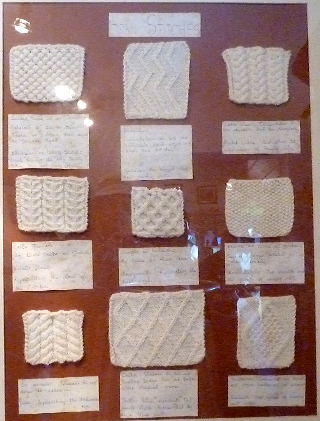
actual art forms pre date the Christian era. Designs like Cables, Trellis, Jacob’s
ladder, Tree of Life, and the Holy Trinity Stitch all have a spiritual meaning
and are inter laced with folk traditions.
 As the craft developed, certain traditions also grew
around patterns and designs. One is about the grouping of certain panels linked
to the fishing families. Also, it was said that the birth of the first son was
commemorated by making a plain sweater with one decorative panel on the front
side. As sons were added, panels were added with different designs on either
side. When a boat was shipwrecked, the pattern identified the body. Families guarded
their patterns. These were passed on only to the daughters of the same family. Only
through marriage and birth of sons would the pattern disseminate around
locally.
As the craft developed, certain traditions also grew
around patterns and designs. One is about the grouping of certain panels linked
to the fishing families. Also, it was said that the birth of the first son was
commemorated by making a plain sweater with one decorative panel on the front
side. As sons were added, panels were added with different designs on either
side. When a boat was shipwrecked, the pattern identified the body. Families guarded
their patterns. These were passed on only to the daughters of the same family. Only
through marriage and birth of sons would the pattern disseminate around
locally.
The islanders saw the surroundings to create their patterns.
Stitches like Irish moss which is a symbol of Carrageen moss gathered by the
locals. The Diamond stitch is said to represent the little stone walls
enclosing fields. Sometimes the moss stitch represented the sea weed which fertilized
the ground.
Text and photographs copyright of the author. No part of this article or photographs maybe transmitted or reproduced by any means, electronic, mechanical, photocopying or otherwise, without written permission. Do contact the author on email -- helpthesun@gmail.com